The Essential Guide to Navigation Without GPS
Why Traditional Navigation Still Matters
GPS is reliable until it isn’t. Batteries die. Signals drop in canyons and dense timber. Devices get wet or broken. And in some environments — deep wilderness, international travel, austere operations — you simply may not have access to electronic navigation at all.
More fundamentally: a navigator who depends entirely on a device has transferred all their spatial reasoning to a machine. When that machine stops working, they are lost in the truest sense — not just without coordinates, but without the underlying skill to reconstruct their position. Traditional navigation builds the skill, not the dependency.
The three foundational tools — topographic maps, magnetic compasses, and celestial bodies — have guided exploration, military operations, and survival situations for centuries. Used together and practiced regularly, they provide a navigation capability that no battery can drain and no signal drop can interrupt.
The redundancy principle — always two methods:
— Map + compass as primary system
— Celestial or terrain cues as backup confirmation
— Natural landmarks as continuous cross-reference
A single navigation method that fails is a crisis. Two independent methods that disagree is a problem you can solve. Never rely on one technique alone.
The Three Core Tools: Map, Compass, and Sky
Each traditional navigation tool has a distinct role, a distinct skill curve, and a distinct failure mode. Understanding all three — and how they complement each other — is the foundation of navigating without electronics.
- Understanding map scale and what distances represent
- Reading contour lines for slope, ridge, valley, and saddle
- Recognizing standard symbols for vegetation, trails, water
- Orienting the map to match the terrain around you
- Translating a 2D map into a 3D mental model
- Taking accurate bearings from map to real world
- Adjusting for magnetic declination at your location
- Orienting the map using compass needle alignment
- “Aiming off” to hit linear features deliberately
- Back-bearings for position confirmation
- Locating Polaris via the Big Dipper’s pointer stars
- Using solar position for rough cardinal directions
- Crescent moon orientation for east/west at dawn/dusk
- Recognizing key constellations as direction anchors
- Sextant use for latitude calculation (advanced)
Reading Topographic Maps: Translate Paper Into Terrain
A topographic map is the most information-dense navigation tool available — but only to someone who can read it. A person who cannot interpret contour lines is carrying a paper weight. A person who can is carrying a three-dimensional terrain model that predicts what they’ll encounter before they get there.
Contour lines: the core language
Contour lines connect points of equal elevation. Every point on a given contour line is at the same height above sea level. The vertical distance between adjacent lines — the contour interval — is printed in the map legend. When lines are close together, the terrain is steep. When they’re spaced far apart, the ground is relatively flat.
Specific contour patterns tell you what kind of terrain feature you’re looking at. A ridge appears as a series of V or U shapes pointing downhill. A valley or drainage shows the same shapes pointing uphill, toward higher ground. A saddle looks like an hourglass between two high points. A cliff shows contour lines so close they nearly overlap or actually touch. Learning to read these shapes on paper and recognize them in the field is the foundation of terrain association navigation.
Scale, symbols, and real-world translation
Map scale tells you the ratio between map distance and real-world distance. A 1:24,000 scale map means one inch on paper equals 24,000 inches — or 2,000 feet — on the ground. This lets you estimate travel time, identify how far a landmark is, and gauge whether a cross-country route is realistic in your available daylight.
Standard topographic symbols are mostly consistent across U.S. Geological Survey (USGS) maps: blue for water features, green for vegetation cover, black for man-made features and trail routes, brown for elevation contours. A map legend translates any variations. Read the legend before you read the map.
Orient your map before you read it, every time. Rotate the map until its north aligns with actual north using your compass. Everything on the map now matches what you see around you — the valley that runs northeast on paper runs northeast in front of you. This single habit prevents the majority of map-reading errors.
Compass Navigation: Taking Bearings and Correcting for Declination
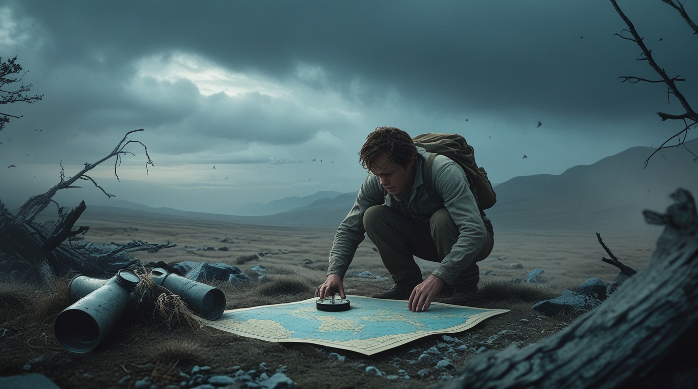
A compass without technique is just a needle. Technique without a compass is guesswork. The combination — a properly used compass and a map you can read — gives you the ability to navigate precisely to any point you can identify on paper, through terrain you’ve never seen, in any weather that still allows you to hold the compass level.
Taking an accurate bearing — step by step
Magnetic declination: the error you cannot ignore
Magnetic north — where the compass needle points — differs from true north by a value that changes depending on where you are on Earth. In the continental United States, this declination ranges from roughly 20° west in Maine to 20° east in the Pacific Northwest. At 20° of uncorrected error, you will miss a point one mile away by over 600 feet. At five miles, you can miss your target by more than a third of a mile. The local declination value is printed in the margin of every topographic map — there is no reason to ignore it.
Failing to account for declination is the most common compass navigation error. It produces consistent, cumulative directional drift — you travel in a slightly wrong direction the entire time and arrive in the wrong place. Before any navigation trip, confirm the current declination for your area. Declination values shift over years; a map printed a decade ago may show a value that is now several degrees off.
Celestial Navigation: Direction From the Sky
Celestial navigation requires no equipment for basic direction-finding — only knowledge and the ability to observe. Its limitation is weather: clouds defeat it entirely. Its advantage is complete independence from any manufactured tool. In a situation where your compass is lost or broken, knowing how to extract cardinal direction from the sky can be the difference between finding your way and wandering.
Finding north with Polaris
In the Northern Hemisphere, Polaris (the North Star) sits within approximately 1° of true north and does not appear to move as the Earth rotates. Finding it is a two-step process: locate the Big Dipper, then follow the two “pointer stars” at the outer edge of the Dipper’s bowl upward (away from the handle) — they point directly to Polaris. The distance to Polaris is roughly five times the distance between the two pointer stars. Once you have Polaris, you have true north, and all other directions follow.
Using the sun as a direction reference
The sun rises in the east and sets in the west everywhere on Earth — though the exact azimuth shifts with season and latitude. At solar noon (the sun’s highest point in the sky), the sun is due south in the Northern Hemisphere and due north in the Southern Hemisphere. A shadow cast at noon points directly north in the Northern Hemisphere. Between sunrise and solar noon, the shadow points northwest; between noon and sunset, it points northeast. These are rough approximations useful for maintaining general direction, not for taking precise bearings.
Moon orientation: a fast backup
A crescent moon provides quick directional reference. Draw an imaginary line through the tips of the crescent and extend it down to the horizon — in the Northern Hemisphere, that intersection point is roughly south. Before midnight, a crescent moon is in the western sky and sets after the sun. After midnight, a crescent rises in the east ahead of the sun. These patterns require memorization but provide a quick sanity check when the stars are partially obscured.
Practice celestial navigation at home before you need it in the field. On a clear night, find Polaris using the Big Dipper, then verify with a compass. Note the difference — ideally it should be less than 2°. Understanding what “close enough” looks like builds confidence in the method before the stakes are real.
Reading Natural Terrain Cues: When Tools Are Unavailable
Natural cues are neither as accurate as a compass nor as systematic as map reading, but they provide continuous environmental feedback that supplements your primary navigation system. They’re also available when nothing else is — no battery, no map, no clear sky required for most of them.
- In the Northern Hemisphere, moss grows predominantly on the north side of trees and rocks — the side with less direct sunlight. Useful for orientation, not for precise bearing.
- Snow on mountain slopes tends to persist longer on north-facing aspects. In spring, south-facing slopes melt first and reveal dark earth while north aspects remain snow-covered.
- In mountainous terrain, major valleys often run roughly north-south while ridgelines frequently run east-west — though this varies significantly by local geology.
- Trees in open areas typically show more branch growth on their southern side, toward maximum sun exposure.
- Water flows downhill — following a stream or river downstream consistently leads to lower elevation and typically toward larger bodies of water or human settlement.
- The watershed you’re in determines where drainages lead. Knowing which watershed you’re traveling through (identifiable from a topo map) tells you whether following water takes you toward or away from your objective.
- Confluences — where two streams meet — are identifiable on topo maps as terrain pinch points and serve as excellent position confirmation landmarks.
- Rivers and streams maintain consistent direction over miles, making them reliable linear handrails for navigation in poor visibility conditions.
- Prevailing wind patterns are regionally consistent. In most of the continental U.S., prevailing winds blow from west to east — weather systems and clouds generally move in that direction.
- In coastal areas, sea breezes blow onshore during the day (from water to land) and offshore at night. This pattern is consistent enough to use as a directional reference in familiar coastal terrain.
- Cloud movement indicates upper-level wind direction, which often differs from surface wind. Observing both layers helps distinguish local thermal effects from prevailing weather direction.
- Trees in exposed areas show long-term prevailing wind effects — their canopy and smaller branches lean persistently away from the dominant wind direction.
- Polaris sits within 1° of true north at all times — the most reliable celestial direction indicator in the Northern Hemisphere. Found by extending the Big Dipper’s pointer stars.
- The sun’s position at local noon gives a rough south bearing in the Northern Hemisphere. A stick planted vertically casts its shortest shadow pointing north at solar noon.
- The Southern Cross provides south reference for Southern Hemisphere navigation, functioning similarly to Polaris in indicating the celestial south pole.
- In partially cloudy conditions, even brief star visibility can confirm bearing if you’ve pre-identified key reference points before cloud cover arrived.
Natural cues should be treated as confirmation tools, not primary navigation. Multiple agreeing cues — moss, snow aspect, and water flow all indicating the same direction — are more reliable than any single cue alone. A single contradicting cue signals that you may be misreading the environment or that local conditions differ from the general rule.
Preparing for a GPS-Free Trip: Gear, Skills, and Mental Readiness
Navigation preparation starts before you leave, not when you realize you’re turned around. A GPS-free trip demands that you have done the work in advance: studied the terrain, confirmed your gear, practiced the skills, and established decision rules for what to do if things go wrong.
Essential gear — no single point of failure
- A detailed topographic map of the entire area you will travel — ideally waterproofed or stored in a map case. Know the contour interval, scale, and declination value before departure.
- A quality baseplate compass with adjustable declination. Set declination before you start and verify the setting at a known landmark early in the trip.
- A notepad and pencil for recording pace counts, bearings, time estimates, and terrain notes. Your memory is unreliable under fatigue or stress; the notepad is not.
- A watch for estimating travel time and distance using your known pace speed, and for solar time calculations if needed.
Skills development: controlled environments first
Start practicing in terrain you already know. Navigate a familiar park or trail using only map and compass — resist looking at your phone. Confirm your position at every landmark. This isn’t about proving you can do it; it’s about calibrating how your technique performs in real terrain before the stakes are real. Gradually increase complexity: longer routes, less distinct terrain, lower-visibility conditions. The skill is built incrementally, not in a single outing.
Situational awareness as a continuous habit
Situational awareness in navigation means constantly maintaining a rough model of your position in your head — not a precise GPS coordinate, but a working answer to “where am I on the map relative to the terrain around me?” This requires periodic stops to cross-reference terrain features with what the map predicts should be there. When the terrain and map agree, you’re on track. When they disagree, you stop and resolve the discrepancy before moving further.
STOP when you’re unsure — always:
— Stop — don’t keep moving when uncertain; movement compounds errors
— Think — recall your last confirmed position and what you’ve done since
— Observe — study terrain features around you and match them to the map
— Plan — decide on your next action only after re-establishing position
Continuing to move while lost converts a navigation problem into a search and rescue problem.
Navigating Challenging Environments: Forest, Desert, and Mountain
Each terrain type presents a distinct combination of navigation challenges. The core techniques remain the same — the application changes based on what the environment takes away from you: visibility, landmarks, temperature margin, or time.
- Visibility limited to tens of meters in heavy canopy
- Familiar landmarks obscured by uniform vegetation
- Difficult to identify terrain features without sightlines
- Compass bearings become the primary tool with few backup references
- Micro-navigation: take frequent short bearings, not long ones
- Use pace count to track distance when you can’t see landmarks
- Deliberately aim off linear features (trails, streams) so you know which side to turn when you hit them
- Use drainage crossings as position-fixing landmarks
- Minimal landmarks — repetitive terrain is disorienting
- Heat shimmer and mirages distort distant references
- Extreme temperatures limit the movement window
- Sand can shift paths and obscure tracks rapidly
- Navigate primarily during the golden hours — early morning, late afternoon — when visibility and temperature margins are best
- Use sun position and shadow angle for continuous direction confirmation
- Identify distant terrain features (rock formations, distant ridges) as bearing targets — they don’t shift
- Log water source positions on map before departing; running dry during a navigation error is life-threatening
- Weather changes rapidly — cloud cover can eliminate visibility in minutes
- Terrain features look different from different approach angles
- Route-finding errors have higher consequences at altitude
- Contour lines become dense and hard to read without practice
- Study the map extensively before departure; identify key terrain features from multiple angles
- Use contour line spacing to predict steepness before committing to a route
- Always have a confirmed descent route before ascending — weather may force early retreat
- Use environmental wind and cloud cues to anticipate weather direction and give yourself margin
Common Navigation Errors and How to Catch Them Early
Navigation errors are almost always recoverable early and potentially serious late. The most dangerous pattern is not making an error — it’s continuing to move after making one, accumulating distance in the wrong direction until correction requires major backtracking or produces a genuine emergency.
Losing your bearings
The moment you’re uncertain of your position, stop. Don’t reason that you’ll figure it out as you go — movement compounds errors. Use the STOP protocol above, then reconstruct your position by matching terrain features to the map. If you genuinely cannot reconcile your map with the terrain around you, retrace to your last confirmed position and try again. A confident wrong answer is worse than an uncertain correct one.
Misreading the map
The most common map-reading errors are misidentifying terrain features (a spur ridge mistaken for the main ridge, a small drainage confused with a major one) and failing to orient the map before reading it. Before committing to a direction change, cross-reference at least two independent terrain features with the map. One match could be coincidence. Two independent matches confirm position.
Overreliance on a single technique
Over-trusting any single method — including the compass — produces confidence in a position that may be wrong. Compass bearings accumulate small errors over distance. Terrain association is limited in uniform terrain. Celestial navigation is weather-dependent. Natural cues are regional approximations. The navigator who combines all available methods and notes when they agree — and investigates when they don’t — maintains the most accurate picture of where they actually are.
Regularly practice what’s called a “position fix” every 20–30 minutes of travel. Stop, identify three terrain features visible around you, locate them on the map, and confirm your position triangulates between all three. This habit catches drift early, before small errors have compounded into large ones, and keeps your mental map current even in monotonous terrain.
Compare Products: Cammenga Lensatic Compass vs Davis Instruments Mark 25 Sextant
Two of the most capable traditional navigation instruments at opposite ends of the tool spectrum: a military-standard lensatic compass for land navigation and a precision optical sextant for celestial positioning. Understanding the role each plays — and which belongs in your kit — depends entirely on the navigation challenges you expect to face.
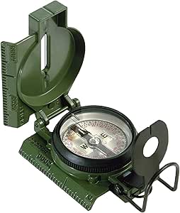
- TypeLensatic (sighting)
- IlluminationTritium — no batteries
- ConstructionAluminum housing, mil-spec
- Military Official✓ Yes
- Declination Adj.Manual (mil-spec)
- Sextant / CelestialN/A
- Best UseLand nav, grid bearings, dense terrain
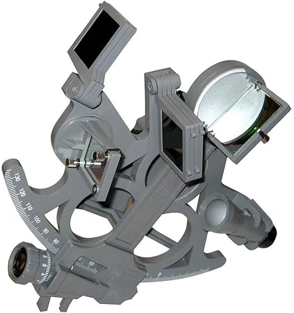
- TypeOptical sextant
- IlluminationLED — arc and drum lit
- Telescope✓ 3×27mm star scope
- Sun Shades✓ 7 shades included
- Beam Converger✓ Full field
- Compass FunctionN/A
- Best UseCelestial positioning, open water, latitude calculation
- Tritium glow — 12+ year life
- Lensatic sighting for precise bearings
- Mil-spec waterproof aluminum
- Full-field beam converger mirror
- LED illumination — arc and drum
- 7 sun shades for solar observations
- Suunto A-10 / A-30
- Silva Ranger 2.0
- Brunton TruArc 15
- National Geographic Trails Illustrated
- USGS 7.5-minute series
- CalTopo custom waterproof print
- Rite in the Rain field notebook
- Aquapac waterproof map case
- Fisher Space Pen or pencil
- Bowditch: American Practical Navigator
- Nautical Almanac (current year)
- HO 229 Sight Reduction Tables